Peering Through the Smoke: Google-Backed Satellites Launch to Revolutionize Wildfire Detection Amidst Worsening Global Blazes

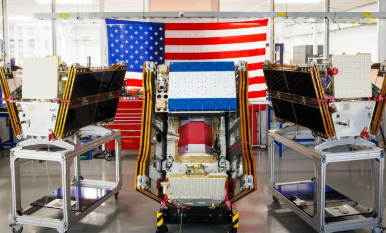
The first three operational satellites of the Google-backed FireSat program have successfully launched into orbit, heralding a new era in wildfire detection capabilities as smoke from hundreds of raging wildfires continues to blanket vast swathes of Canada and the United States. These advanced microsatellites, designed to spot even the smallest of fires, are set to begin providing crucial data to fire agencies across the United States, Australia, and Europe before the close of 2026. This deployment marks a significant milestone in the global effort to combat the escalating threat of wildfires, which are increasingly exacerbated by climate change.
A New Frontier in Wildfire Surveillance
The successful launch aboard a SpaceX Falcon 9 rocket from Vandenberg Space Force Base in California on July 7, 2026, represents a pivotal transition to "initial operational capability" for the FireSat constellation. Managed by the nonprofit Earth Fire Alliance, this program is poised to deliver unprecedented insights into wildfire origins and spread. Following an intensive three-month testing and calibration period, these initial three satellites will commence active data provision, ensuring that every fire-prone region on Earth receives coverage at least twice daily. This regular revisitation rate is critical for early detection, a factor consistently identified by experts as paramount in preventing small blazes from spiraling into uncontrollable infernos.
FireSat distinguishes itself as the first satellite constellation purpose-built exclusively for wildfire detection. Unlike existing general-purpose Earth observation satellites, which may miss nascent or low-intensity fires, FireSat’s specialized design enables it to identify fires as small as five by five meters—approximately 16 by 16 feet. This remarkable precision is achieved through state-of-the-art multispectral imaging technology, capable of penetrating dense smoke and cloud cover, a common challenge that obscures conventional satellite views. The efficacy of this technology was unequivocally demonstrated by a FireSat Protoflight satellite, which launched in March 2025. During its mission, the protoflight satellite collected over one million images, proving its ability to detect subtle, low-intensity blazes that remained invisible to other orbiting platforms.
Strategic Partnerships and Financial Impetus
The ambitious FireSat program is a testament to the power of collaborative innovation, drawing significant financial and technical backing from leading technology and philanthropic entities. California-based satellite manufacturer Muon Space designed and built the microsatellites, leveraging their expertise in developing high-performance spacecraft. Google has committed over $15 million to support the initial deployment phases, underscoring the tech giant’s deepening involvement in climate resilience initiatives. This investment aligns with Google’s broader strategy of applying advanced AI and data analytics to complex global challenges.
Further bolstering the program’s foundation, the Bezos Earth Fund has pledged a substantial $26 million. This commitment from the fund, established by Amazon founder Jeff Bezos to combat climate change, highlights the growing recognition among major philanthropic organizations of the urgent need for innovative solutions in environmental protection. The combined financial muscle and technological prowess of these partners are instrumental in accelerating the development and deployment of the FireSat constellation, transforming a visionary concept into a tangible, operational asset for global fire management.
A Phased Rollout for Global Coverage

The FireSat program operates on a clear, phased deployment strategy aimed at progressively enhancing global coverage and revisit rates. The "early adopter" organizations, which will begin utilizing FireSat data later this year, include critical fire agencies in California and Colorado, regions frequently ravaged by devastating wildfires, as well as international partners in Australia and Portugal, both facing severe wildfire seasons intensified by climate change. These initial users will play a crucial role in refining data utilization and integrating FireSat alerts into their existing response protocols.
Looking ahead, the FireSat program aims for a significant expansion. By 2029, the constellation is projected to provide hourly imagery anywhere in the world, dramatically reducing the time between fire ignition and detection. This accelerated data flow is anticipated to provide fire managers with an unparalleled advantage in deploying resources rapidly. The ultimate vision entails a full constellation of more than 50 satellites, expected to be fully operational by the early 2030s. At this stage, FireSat will achieve an extraordinary revisit rate of every 20 minutes, offering near real-time wildfire monitoring capabilities that could fundamentally alter the landscape of global fire management.
Projected Impact: A Billion-Dollar Benefit and Beyond
The potential benefits of FireSat’s enhanced detection capabilities are profound and far-reaching. The Earth Fire Alliance has released compelling projections, estimating that even an hourly revisit rate by the FireSat constellation could lead to savings exceeding $1 billion in fire damage costs annually. This figure is particularly significant when contextualized against the escalating economic toll of wildfires worldwide. For instance, in the United States alone, the annual cost of wildfire suppression often exceeds $3 billion, with total economic damages, including property loss, health impacts, and business disruptions, reaching tens of billions. The 2020 California wildfire season, for example, resulted in over $12 billion in insured losses.
Beyond financial savings, the environmental and social impacts are equally compelling. FireSat is projected to prevent nearly 22 million tons of carbon emissions each year by detecting and containing fires before they grow large. This is a critical contribution to climate mitigation efforts, as wildfires are significant contributors to atmospheric greenhouse gases. Furthermore, the program is expected to protect an estimated 3,500 homes and safeguard 1.3 million acres of land from destruction, preserving ecosystems, biodiversity, and human livelihoods. The ability to intervene early could also drastically reduce the hazardous air pollution that frequently impacts densely populated areas, protecting public health.
AI’s Central Role in Data Analysis and Prediction
Google Research plays a pivotal role in maximizing the utility of FireSat’s data stream through the application of advanced artificial intelligence models. These AI systems are designed to process the vast quantities of multispectral imagery generated by the satellites, comparing operational FireSat data with historical images to accurately identify even the most subtle fire signatures. This sophisticated analysis helps to filter out false positives and pinpoint nascent blazes with high confidence.
Crucially, Google’s AI models also contribute to predictive modeling of wildfires. By integrating FireSat data with other environmental factors such as weather patterns, fuel loads, and topography, the AI can forecast potential fire behavior and spread. This predictive capability empowers fire agencies to make more informed decisions regarding resource allocation, evacuation orders, and strategic containment efforts. Google celebrated the launch of the first operational FireSat satellites by characterizing the event as "another tangible step forward in putting practical AI to work for climate resilience," highlighting the transformative potential of integrating cutting-edge technology with environmental stewardship.
The Broader Context: Climate Change and the Wildfire Crisis

While technological advancements like FireSat offer a beacon of hope, it is imperative to view them within the broader, increasingly grim context of global climate change. The Silicon Valley’s accelerating deployment of AI models, while offering solutions, simultaneously presents a paradox: the energy demands of these powerful computing systems are contributing to the very climate crisis they seek to address.
AI’s Environmental Footprint
The proliferation of large AI data centers requires massive amounts of electricity, a demand often met by new natural gas projects in the United States. Projections indicate that the greenhouse gas emissions from this data center boom could collectively exceed 129 million tons per year. To put this into perspective, this is roughly equivalent to the annual emissions of 28 million passenger vehicles or the total emissions of a country like Belgium. Google itself has acknowledged the formidable challenges of sourcing enough clean energy projects to offset the potential emissions from its energy-hungry data centers. The company’s electricity usage, for instance, surged by a staggering 37 percent in 2025, largely driven by its expanding AI infrastructure. This tension between technological progress and environmental impact underscores the need for sustainable AI development and rapid decarbonization of energy grids.
The Intensifying Wildfire Season of 2026
FireSat’s launch arrives at a critical juncture, coinciding with one of the most severe wildfire seasons on record, particularly across North America. The boreal forests of Canada have been ablaze for months, generating immense smoke clouds that have traversed continents. As of July 17, 2026, the Canadian Wildland Fire Information System reported nearly 900 active wildfires across the country. To date, Canada has experienced over 3,600 wildfires, scorching more than 6.6 million acres—an area larger than the state of Maryland. Dozens of these fires are classified as "out of control," a stark term indicating that fire agencies, facing limited resources and prioritizing firefighter safety, are forced to monitor them rather than actively suppress them.
The human cost of these fires has been immense. Thousands of people in First Nations communities, often located in remote forested areas, have been forced to evacuate their ancestral lands, disrupting lives and cultural practices. The smoke plumes have caused hazardous air pollution for over 100 million people across Canadian and US cities, from the Midwest to the Mid-Atlantic and Northeast, leading to widespread health advisories, school closures, and disruptions to daily life. Air Quality Index (AQI) readings in major cities have frequently soared into the "unhealthy" or "very unhealthy" categories, posing serious risks to vulnerable populations.
Climate Change: The Overarching Driver
Scientific consensus firmly links the increasing size and intensity of these wildfires to climate change, driven by anthropogenic greenhouse gas emissions from fossil fuels. Drier conditions, longer and hotter fire seasons, and an increase in lightning strikes—a common ignition source in boreal forests—are all direct consequences of a warming planet. Canada has experienced two of its most destructive wildfire seasons in 2023 and 2025, with the last three fire seasons consistently ranking among the ten worst on record.
Werner Kurz, a retired senior research scientist at Natural Resources Canada, articulated the long-predicted reality to The Atlantic: "What is unfolding is what climate and forest scientists have been predicting for 30 years. That as the world gets hotter and drier, we are exposing forests to more and more risk, and the old strategies of fire suppression are simply being overwhelmed." This sentiment is echoed by fire management professionals globally, who increasingly find traditional suppression tactics inadequate against the scale and ferocity of modern megafires.

Challenges in Fire Suppression and Resource Allocation
Fighting wildfires, especially in vast, mostly uninhabited forest regions, requires specialized and expensive resources, primarily fixed-wing air tankers and heavy-lift helicopters. These aircraft are essential for dropping fire retardants and water, and for transporting firefighting crews to remote sites. However, the burden of acquiring and contracting for such aerial firefighting assets typically falls on individual Canadian provinces, leading to disparities in capacity. In recent years, every available aircraft has often been deployed, straining resources to their limits. Recognizing this systemic challenge, the Canadian federal government responded by leasing 10 new aerial firefighting aircraft in May 2026, making them available as surge assets to provinces in dire need.
Beyond suppression, comprehensive wildfire management also necessitates proactive strategies like prescribed burns, which help reduce fuel loads and restore ecological balance to fire-adapted landscapes. However, these vital ecosystem management practices are often underfunded and politically challenging to implement, leaving forests vulnerable to catastrophic blazes when natural or human-caused ignitions occur.
Looking Ahead: A Holistic Approach to a Global Crisis
The FireSat program represents a significant leap forward in humanity’s capacity to detect and respond to wildfires. Its advanced technology and ambitious global coverage plan offer a powerful tool in mitigating the immediate impacts of these destructive events. However, the context of its launch – amidst raging fires and increasing climate concerns – serves as a stark reminder that technology alone cannot solve the multifaceted wildfire crisis.
Effective wildfire management demands a holistic approach that integrates early detection with robust rapid response capabilities, sustained investment in ecosystem management practices like prescribed burns, and, fundamentally, aggressive global action to mitigate climate change. As Jeremy Hsu, a seasoned reporter covering deep tech and AI, aptly highlights, Google’s financial and technical support for AI-powered wildfire detection is incredibly helpful, but "wildfire detection is just one of multiple elements necessary to prevent blazes from spiraling out of control." The ultimate success in protecting communities, environments, and the planet from the ravages of wildfire will depend on a concerted, multi-pronged strategy that addresses both the symptoms and the root causes of this accelerating global challenge.