Google-Backed FireSat Constellation Launches, Revolutionizing Wildfire Detection Amid Escalating Global Crisis

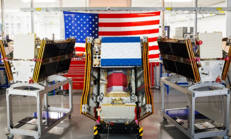
As vast plumes of smoke from hundreds of raging wildfires continue to choke communities across Canada and the United States, the first three operational satellites of the Google-backed FireSat program have successfully launched into orbit. This pivotal deployment marks a significant leap forward in global wildfire detection capabilities, promising to identify even nascent blazes in fire-prone regions across the United States, Australia, and Europe before the year’s end. The launch, executed by a SpaceX Falcon 9 rocket from Vandenberg Space Force Base in California on July 7, 2026, ushers in an "initial operational capability" for the FireSat constellation, an initiative spearheaded by the nonprofit Earth Fire Alliance. Following a rigorous three-month testing period, these advanced microsatellites will commence actively feeding critical data to fire agencies worldwide, ensuring that every high-risk area is monitored at least twice daily.
The FireSat Initiative: A New Era of Detection
The FireSat constellation represents a paradigm shift in wildfire monitoring, being the first satellite network purpose-built exclusively for detecting wildfires. Unlike existing satellite systems that may overlook smaller, less intense fires, FireSat’s sophisticated technology is designed to pinpoint these critical early indicators. The satellites themselves are the brainchild of Muon Space, a California-based satellite manufacturer, and have garnered substantial financial backing from leading philanthropic and technology giants. Google has committed over $15 million towards the initial deployment of the constellation, underscoring the tech giant’s investment in climate resilience solutions. Further significant support has come from the Bezos Earth Fund, which pledged an impressive $26 million to address the global wildfire challenge. This blend of technological innovation and strategic funding highlights a growing recognition of the urgent need for advanced tools in combating the escalating threat of wildfires.
Unprecedented Precision: Peering Through the Smoke
Central to FireSat’s groundbreaking capability is its multispectral imaging technology. Each satellite is equipped with advanced sensors capable of penetrating dense smoke and cloud cover, a common impediment for conventional satellite observation during active fire events. This allows FireSat to detect fires as small as five by five meters—approximately 16 by 16 feet—a level of precision previously unattainable. The efficacy of this technology was demonstrably proven by a FireSat Protoflight satellite, which launched in March 2025. During its mission, the protoflight unit collected over one million images, showcasing its remarkable ability to identify low-intensity blazes that remained entirely invisible to existing satellite systems. This pre-operational success provided crucial validation for the full-scale deployment, confirming that FireSat can indeed offer an unparalleled early warning system. The multispectral approach leverages different wavelengths of light, including infrared, which is particularly effective at detecting the heat signatures of fires, even when obscured by smoke or vegetation. This is a critical advantage over visible light sensors, which are easily blinded by smoke.

Expanding Global Coverage and Future Vision
The immediate impact of the initial three satellites will be felt by "early adopter" organizations, including fire agencies in California, Colorado, Australia, and Portugal, who are slated to begin utilizing FireSat data later this year. These regions, frequently ravaged by destructive fire seasons, stand to benefit immensely from the enhanced detection capabilities. The FireSat program has an ambitious roadmap for expansion. As more satellites are launched, the constellation aims to provide near real-time imagery from anywhere in the world on an hourly basis by 2029. The ultimate goal, projected for the early 2030s, is to deploy a full constellation of more than 50 satellites, reducing the revisit time to an extraordinary 20 minutes. Such frequent updates would offer fire management teams an unprecedented, dynamic view of evolving fire situations, allowing for faster, more informed responses. This level of persistent surveillance is crucial for tracking fire progression, identifying new ignitions, and optimizing resource deployment in rapidly changing wildfire environments.
The Economic and Environmental Promise of Early Detection
The potential benefits of FireSat’s early detection capabilities extend far beyond immediate response. The Earth Fire Alliance has conducted projections indicating that even an hourly revisit rate from the FireSat constellation could lead to substantial economic and environmental savings. These projections suggest a potential saving of over $1 billion in fire damage costs annually. Furthermore, the ability to contain fires at an earlier stage is estimated to prevent nearly 22 million tons of carbon emissions, a significant contribution to climate change mitigation. Critically, early detection could also protect approximately 3,500 homes and safeguard 1.3 million acres of land from devastation each year. These figures underscore the profound positive impact that timely intervention, facilitated by advanced satellite monitoring, can have on both human communities and ecological systems. The ability to distinguish between prescribed burns and unwanted ignitions, or to identify illegal burning activities, also adds a layer of intelligence for fire authorities.
Adopters on the Front Lines
The selection of California, Colorado, Australia, and Portugal as initial beneficiaries highlights the global nature of the wildfire crisis and the immediate need for advanced solutions in these high-risk areas. California, with its perennial wildfire challenges, has long sought technological edges to combat its fire seasons. Australia has experienced some of the most catastrophic bushfire seasons in recent memory, making early detection a national priority. Portugal, too, has grappled with increasingly intense and frequent wildfires, often exacerbated by drought conditions and dense forest fuels. The data provided by FireSat will enable these agencies to deploy resources more efficiently, target initial attacks with greater precision, and potentially prevent small fires from escalating into uncontrollable infernos that threaten lives, property, and natural ecosystems. The integration of FireSat data with existing ground-based and aerial surveillance systems promises to create a comprehensive, multi-layered approach to wildfire management.

The Broader Wildfire Context: A Planet Under Siege
The launch of FireSat occurs against a backdrop of intensifying global wildfire activity, a phenomenon intrinsically linked to climate change. Across the planet, hotter, drier conditions are creating landscapes primed for ignition and rapid fire spread. The past decade has seen record-breaking wildfire seasons in various regions, including the Amazon, Siberia, Australia, and the western United States. These fires are not merely increasing in frequency but also in intensity and scale, often burning hotter and faster than historical norms. The traditional strategies of fire suppression, which have long relied on rapid response and aggressive containment, are increasingly being overwhelmed by the sheer size and ferocity of these mega-fires. This escalating crisis underscores the urgency behind initiatives like FireSat, as early detection becomes an ever more critical component of wildfire management in a warming world. Scientists consistently point to the direct correlation between rising global temperatures, prolonged droughts, and the extension of fire seasons as key drivers of this trend.
Canada’s Fiery Summer of 2026: A Case Study
The current wildfire crisis engulfing Canada’s vast boreal forests serves as a stark, real-time illustration of the challenges FireSat aims to address. This summer, wildfires have forced thousands of people, particularly in vulnerable First Nations communities, to evacuate their homes, disrupting lives and causing immense distress. The immense smoke clouds generated by these blazes have spread far beyond Canada’s borders, blanketing major Canadian and US cities in hazardous air pollution and affecting the health of over 100 million people. This situation is not an anomaly; Canada has experienced two of its most destructive wildfire seasons in 2023 and 2025, with the last three fire seasons ranking among the top ten worst on record.
Werner Kurz, a retired senior research scientist at Natural Resources Canada, articulated the grim reality to The Atlantic: "What is unfolding is what climate and forest scientists have been predicting for 30 years. That as the world gets hotter and drier, we are exposing forests to more and more risk, and the old strategies of fire suppression are simply being overwhelmed." The sheer scale of these fires in mostly uninhabited forest regions presents immense logistical challenges. Fighting them requires specialized resources such as fixed-wing air tankers capable of dropping fire retardants and heavy-lift helicopters for transporting firefighting crews to remote sites. Historically, individual Canadian provinces have borne the primary burden of acquiring or contracting these expensive assets. In recognition of the escalating crisis, the Canadian federal government stepped in this year, leasing 10 new aerial firefighting aircraft to serve as surge assets for provinces. As of July 17, the Canadian Wildland Fire Information System reported nearly 900 active wildfires across the country, with over 3,600 fires to date having scorched more than 6.6 million acres. Dozens of these fires are currently classified as "out of control," meaning they are being monitored rather than actively suppressed—a grim decision fire agencies are forced to make when balancing limited resources against the inherent risks to firefighters’ lives. This highlights the crucial role FireSat could play in prioritizing resources and identifying new threats that demand immediate attention.
The AI Paradox: Innovation’s Carbon Footprint

While Google’s financial and technical support for AI-powered wildfire detection through FireSat is undeniably valuable, it also brings into focus a critical paradox: the significant climate costs associated with Silicon Valley’s rapid deployment of new AI models. The burgeoning demand for AI computing power necessitates massive data centers, which consume enormous amounts of electricity. A growing concern is that this demand is often met by new natural gas projects in the United States, which, taken collectively, could emit more than 129 million tons of greenhouse gases annually. Google itself has acknowledged the formidable challenge of deploying sufficient clean energy projects to offset the potential emissions from its increasingly energy-hungry data centers. The company’s electricity usage, driven by its AI buildout, reportedly surged by 37 percent in 2025 alone.
This creates a complex narrative: while AI offers powerful tools for climate resilience, such as wildfire detection and predictive modeling, its underlying infrastructure contributes to the very climate change it seeks to mitigate. Google Research plans to leverage its AI models to analyze FireSat data, comparing it with historical imagery to accurately identify even minute fires and to inform predictive modeling of wildfire behavior. Google celebrated the FireSat launch as "another tangible step forward in putting practical AI to work for climate resilience." However, the broader environmental footprint of AI development remains a crucial consideration, requiring ongoing innovation in sustainable computing and renewable energy infrastructure to truly align technological progress with climate goals. The ethical implications of AI development also extend to resource allocation and ensuring that the benefits of such technologies are equitably distributed, especially to communities most vulnerable to climate impacts.
Beyond Detection: A Holistic Approach to Wildfire Management
Ultimately, while advanced detection systems like FireSat are incredibly helpful, they represent only one element within a comprehensive wildfire management strategy. Preventing blazes from spiraling out of control requires a multi-faceted approach that also includes robust resource allocation for fire agencies, proactive ecosystem management through practices like prescribed burns, and effective suppression of unwanted fires. Global warming continues to exacerbate the challenges faced by these agencies, making their job increasingly arduous. The FireSat program offers a powerful new eye in the sky, providing vital intelligence for fire responders. However, its success will depend not only on the technological prowess of the satellites but also on the capacity of human systems to act upon that intelligence. This includes adequate funding for firefighting personnel and equipment, community education, and policy frameworks that support long-term ecological health and resilience in fire-prone landscapes. The fight against wildfires is a complex battle, where technology, policy, and human effort must converge to protect communities and ecosystems in an era of unprecedented climate challenges.